Herontdek jouw wereld bij Atlas en Kaart
Voor je antieke kaart, prent en plattegrond
Atlassen en boeken
Voor je antieke kaart, prent en plattegrond
Atlassen en boeken
Alleen originele kaarten en prentenOp atlasenkaart.nl vindt u alleen orginele kaarten en prenten te koop.U ontvangt een certificaat van echtheid bij elke kaart of prent! Uitgelicht:De kaarten van de Maan (met achterop alle namen van de kraters), Madagaskar (voor de prinses van Madagaskar) en New York met het mooie stratenpatroon:   |


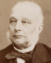
Uw gastheer
Jacob Kuyper:
Nieuw:
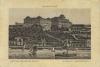
Budapest, Kテカnigl. burg in ofen, Kirテ。lyi vテ。r palota
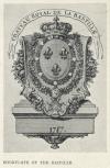
Bookplate of the Bastille
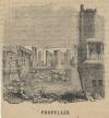
Propylees
Atlas en Kaart: Herontdek jouw wereld
Jacob Kuyper:
Nieuw:
Budapest, Kテカnigl. burg in ofen, Kirテ。lyi vテ。r palota
Bookplate of the Bastille
Propylees
Atlas en Kaart: Herontdek jouw wereld
aanwinsten | gebruik beeldmateriaal | inspired by:
 | privacy
Niets mag zonder toestemming van deze site worden overgenomen lees hier